- Inspire
- Innovate
- Integrate
- Home
- Conserve Solutions Inc
- Scan to BIM Services in US | Precise Point Cloud to BIM Modeling for Construction & Design
Scan to BIM Services in US | Precise Point Cloud to BIM Modeling for Construction & Design
What is scan to BIM?
Scan to bim services in the US is an advanced process that captures 3D data of existing structures or sites and converts it into intelligent Building Information Models (BIM). These models serve as digital twins, allowing architects, engineers, and construction professionals to plan, design, and manage infrastructure projects with unparalleled accuracy and efficiency.With the adoption of 3D scan to BIM in US, this process becomes even more streamlined, ensuring precise and data-rich models for better decision-making.
We are excited that Conserve Solutions is expanding its expertise by launching Scan to BIM in US services specifically to meet US standard codes including NBIMS-US (National BIM Standard – United States), ISO 19650, AIA E202 & G202, CIC BIM Protocol, International Building Code (IBC), National Fire Protection Association (NFPA) Codes, National Electrical Code (NEC), ASHRAE 90.1. we can now offer highly accurate, data-rich 3D models that comply with US industry standards, further strengthening our 3D scan to BIM in US capabilities.
This expansion allows us to support projects across the US, from new construction to renovations, ensuring precision in design, integration of architectural, structural, and MEP systems, and alignment with local building codes and regulations. Our Scan to BIM in the United States services will improve project workflows, enhance collaboration, and help avoid costly mistakes, providing clients with a complete and effective solution for their US-based building projects.
How does Scan to BIM work?
The Scan to BIM process converts the physical attributes of a building or site into a data-rich 3D model. This innovative method eliminates the need for traditional tools like tape measures, offering a far more precise and efficient approach to capturing spatial data. Scan to BIM in the US is often compared to 3D photogrammetry and can be integrated with augmented reality (AR) to provide immersive experiences.
A laser scanner captures data by emitting laser beams, creating a point cloud representing the scanned environment. This data is then imported into BIM software to generate a 3D model, integrating architectural, structural, and MEP components. making the point cloud scan to BIM process highly effective for accurate project modeling. The laser scan to BIM process significantly improves project accuracy and efficiency, particularly for renovation and retrofitting projects, enabling faster decision-making, reducing errors, and improving collaboration across design and construction teams.
Explore the Scan to BIM Services, All Under One Roof, With Conserve Solutions
Join us for results you can trust
Our Approach to
How Conserve can help
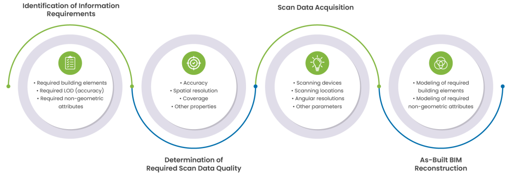
Conserve Solutions offers high-precision Scan to BIM in US services using advanced methodologies and technology. They validate scanner positions, process individual scans, and register them to create a unified point cloud model. This data is processed and combined using specific software as part of the point cloud scan to BIM workflow. The model is then integrated into CAD, BIM, GIS applications and web platforms. Our digital survey total stations validate scanner positions for accurate point cloud modeling to ensure precise measurements. After that, laser scanners gather millions of surface points every second to record 360-degree data. This data is then processed and integrated into the laser scan to BIM workflow, enabling reliable 3D models that can be utilized for future planning, design, and construction needs.
Data Collection
We use digital survey total stations to validate scanner positions in the areas to be captured. This ensures high precision, with point cloud modeling accuracy between 2mm and 5mm.
Laser scanners capture 360-degree measurements, collecting millions of points per second. Once scanning is complete, the data is processed in-house.
Data Analysis
Then by using the processing software where all the individual scans are registered and connected to form your unique point cloud model which suits as an input into BIM applications
Data Processing
3D scanned data can be combined with CAD, GIS, and web data platforms, enabling engineers to make well-informed real-time decisions. The point cloud model’s integration with BIM allows you to complete the work quickly and accurately. The 3D point clouds will be converted into a comprehensive Building Information Model in native formats
Benefits of
Scan to BIM

Captures highly accurate as-built conditions, minimizing discrepancies and ensuring data reliability. Accelerates on-site data collection, significantly reducing project timelines and improving productivity. Minimizes costly rework and errors, optimizing resource allocation and project budgets. Facilitates effective coordination across project stakeholders with detailed, data-enriched 3D models. Aligns effortlessly with design, construction, and facility management processes, management processes, enhancing overall project execution. Provides accurate, high-resolution 3D models for superior spatial understanding and informed decision-making. Delivers accurate as-built records for maintenance, retrofitting, or future
Why choose
conserve solutions?
Proven Track Record
We have a proven record of accomplishment of successfully delivering Scan to BIM in United States solutions for a diverse range of projects, from small-scale renovations to large-scale infrastructure developments.
Clash Detection & Resolution
Our cost-effective Scan to BIM services in the US help optimize project budgets by minimizing rework and maximizing efficiency in the design and construction phases.
Collaborative Approach
We believe in fostering strong partnerships with our clients, working closely with them throughout the entire project lifecycle to ensure their needs are met and expectations exceeded.
Client Satisfaction
We prioritize client satisfaction above all else, striving to deliver exceptional results that consistently exceed expectations.
Frequently Asked Questions
FAQ's
A dedicated Scan to BIM modeler from Conserve Solutions can start within a few days of receiving your scan data and project requirements, ensuring quick and efficient project delivery.
The process begins with laser scanning to capture precise spatial data, which is then processed into a point cloud. The point cloud is imported into BIM software to create a detailed 3D model that aligns with the physical structure’s specifications.
- Renovation, restoration, and extension projects
- As-built documentation for facility management
- Clash detection and coordination
- Digital twins for predictive maintenance
- Construction planning and progress monitoring
We provide BIM models in Revit (RVT), IFC, DWG, PDF, and other formats compatible with CAD, BIM, and GIS platforms.
Laser scanning produces a point cloud, which is a dense collection of data points representing the scanned environment. This data is processed and converted into a detailed 3D BIM model.
Get in Touch
Have Any Other Questions?
Are you ready to elevate your design journey?
The SCAN to BIM revolution begins now!"
Quick Links
Copyrights © 2026. Conserve Solutions. All Rights Reserved.
BIM Data, Cost & Handover Services
BIM Coordination & Constructability
BIM Modelling & Digital Delivery
Discipline BIM Modeling (Architectural, Structural, MEP)
BIM Automation & Digital Engineering
BIM Data, Cost & Handover Services
Structural & Steel Detailing Services
Architectural Design, Visualization & Presentation Support
BIM Coordination & Constructability
BIM Modelling & Digital Delivery